
Description
Leo Swan Memorial Lecture
This talk is part of the week long Summer Series 2025. This year the focus is on the Boyne Valley which was also
the target of our outings in May.
Please note that if you wish to attend all five talks, you should become an RHS member for €25 which will give you free access to these talks and also to the three other talks in the rest of the year.
When you book this talk on-line, you will receive an email with the link to the on-line version. You are also very welcome to attend the talk in person.
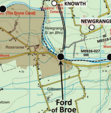
The Ford of Broe
The recent identification of a 1.5km routeway connecting the Ford of Broe at Newgrange/Rossnaree with Knowth (JIA 2024), highlights how time-honoured techniques like field-walking, map analysis and local enquiry can yield results not readily apparent via high-tech methodologies such as LiDAR and drone photography. While the latter have generated much new archaeological data on the Brú na Bóinne World Heritage Site (WHS), several baseline aspects of the historic landscape have been overlooked or only partially examined, e.g. field-name recording, field-boundary mapping, hedgerow survey and road network analysis. This presentation will reprise the types of data used to identify the Broe-Knowth routeway, and will shine a light on three other ancient routeway fragments in the WHS: from Dowth to Cloghalea (Davis et al. 2010 and 2013, ‘raised walkway’), at King William’s Glen (‘Williamite Encampment’), and at the junction of the Mattock-Devlin rivers (Áth nGabla).
Paul Gosling
